As we have seen in this column, drones are extremely versatile, and new technologies are increasing their effectiveness for farmers and others daily. Drone fundi Rolf Schlub and his team (www.terracam.co.za) are developing their own systems for large-scale agricultural mapping using advanced multi-spectral cameras. A drone flies at a pre-determined altitude following a grid pattern over the site. It takes photographs at certain intervals, which are then stitched together using specialised photogrammetry software.
“From this, we can extract volumes, contours, gradients and so on,” says Schlub. The data is then used to make ‘3D digital surface models’ and other kinds of maps. Depending on weather conditions, the drones can cover up to 1 000ha/day.
“We can operate the drones from 3km away. The flight time of our fixed-wing drones is 45 minutes, while our multi-rotors carry more payload and hence only fly for 10 to 15 minutes.“
The TerraCopter platform can be fitted with either an RGB camera for normal photography or a thermal camera for airborne thermography or night-time flying. The cameras are mounted on gyro-stabilised gimbals for super-smooth images and downlink to the operator on the ground, who wears video goggles.
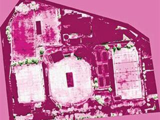
A near-infrared (NIR) camera mounted on a fixed-wing drone can monitor plants. “Since plants can’t convert infrared into food, it’s reflected and then absorbed by our NIR camera, enabling us to determine how vegetation is photosynthesising,” says Schlub.
If health problems are spotted, action can be taken immediately. “Using a raster computation of six-channel orthophotos, we can also determine NDVI and vegetation stress patterns,” he says (see picture).

