

Technology is like a dog. You need to find one that does the right job for you. This is the opinion of Mico Stander, agricultural consultant at Agrimotion, based in Somerset West. “For example, you’re not going to get a dachshund to do the job of an Anatolian sheepdog,” he says.
In the same way, spatial technology is recognised internationally as a valuable tool with excellent potential for improving farming efficiency. But the technology is not reaching its full potential because there is still uncertainty about its value and benefits.
“For many farmers, technology is just another gadget, almost like a toy. Value has to be added to unlock its full benefit,” Stander says.
Available Technologies
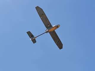
Satellites, aircraft, and unmanned aerial vehicle (UAV) systems, commonly referred to as drones, are the aerial technologies most often used in the agricultural industry. “These technologies allow for the use of remote sensing to identify certain production trends. The tools take the human factor out of decision- making, so farmers can make better informed decisions,” Stander says.
According to him, satellites are a more cost-effective solution when a farmer needs to obtain information about large areas and preparation time is not a constraint. Although the process of collecting data via a satellite is quick, planning can take up to two weeks. Drones on the other hand, are able to respond much more rapidly, but cannot cover a very large area.
In the Western Cape, fruit farmers can access data from this technology at no charge from Fruitlook (www.fruitlook.co.za), which is funded by the Western Cape Department of Agriculture. Satellite technology allows weekly updates on nine growth parameters, including growth, moisture and minerals.
Fruitlook allows farmers to build up a long-term database of these parameters, enabling them to compare different orchards or vineyards as well as trends for different seasons. It also allows farmers to benchmark themselves against each other and identify ways to improve production efficiency.

“The array of applications is still being explored but the most common is assessing how efficiently water is being used, which is a growing need, especially in the 2015 to 2016 season,” Stander says. “By improving their water use efficiency, farmers will be able to reduce water usage and pumping costs, thereby improving yield.”
Drones, on the other hand, provide more detailed information than satellites and farmers have better control over their usage.
According to Stander, the monitoring of fruit development at different stages of development is one of the top applications of this technology, especially in problem or high-value areas in orchards.
Good weather
For both technologies to operate optimally, climatic conditions have to be optimal, as remote sensing cannot be undertaken in overcast weather and drone readings are influenced by windy conditions. To effectively compare data, readings for both technologies should be taken at the same time of day, as plant stress levels vary throughout the day according to climatic conditions. Plants, for example, are under less stress in the morning than in the afternoon when the sun is at its hottest.
Flying legislation
Stander is very positive about local legislation that requires operators to be licensed if the drones are used for other than recreational purposes. Getting a drone licence is similar to getting a driver’s licence for a vehicle, with applicants having to pass practical and theoretical tests. This will help protect the industry and limit the number of ‘fly-by-night’ operators, he says.
Remote sensing
Aerial technology uses cameras to measure different crop parameters, by means of remote sensing. The measurement equipment makes use of geospacial technology for the collection, integration and management of geographic data. Stander explains that the type of lens used on the camera will determine the reading received.
Agrimotion bases its recommendations on the normalised difference vegetation index (NDVI), a growth index using red and near-infrared light as inputs. Other indices, such as those used by geologists to identify minerals, rely on different wavelengths in the visible and infrared light spectrum. Stander emphasises that “it is a matter of finding the correct technology for the job”.
He points out that NDVI is built on the principles of photosynthesis. Healthy plants use red light and blue light to photosynthesise and reflect infrared and green light. “You can’t see infrared light with your naked eye, but you can see the green light that is reflected.
Thus, by comparing the ratios of red and infrared light reflected from a plant, we can assess the level of stress the plant is experiencing.”
The data identifies where stress is experienced, but not the cause of stress. Orchards have to be physically evaluated to determine the cause of variations. “Differences may be due to various factors ranging from pests, disease, water stress, nutritional deficiencies, to variations in soil type,” Stander says.
The saying “a farmer’s footsteps are like fertiliser to his trees” still holds true, as a good farmer will know exactly what is happening in each of his orchards, he says. The problem, however, is that farms have become so large that it is no longer possible for farmers to cover the tree rows on foot in all their orchards. They are therefore becoming dependent on new technologies to help identify problem areas and facilitate management on their farms.
“The technologies also help to smooth transition periods, so that it’s easier for new managers or owners to see what’s happening on a farm,” says Stander. Previously, this could have taken years to accomplish.
GPS – the key positioning tool
Global Positioning System (GPS) monitoring is the key to aerial technologies. Stander explains that it allows farmers to link information with a position. “Without it, a remote sensing image is no more than a portrait. With GPS, farmers can pinpoint the exact location of problem areas.
This allows them to treat only these areas, whereas they may have had to treat the entire orchard in the past. GPS in precision farming also allows for the differential application of chemicals and fertilisers, and in effect helps to boost farm profitability by increasing production, while saving costs and reducing wastage.”
The combination of GPS and remote sensing allows farmers to take timeous action. “Remember, the key to successful farming isn’t simply to treat symptoms but to eradicate causes. This can be done by using a precision approach –
do the right thing at the right time at the right place. GPS and remote sensing often allow farmers to identify where interventions are needed before stress becomes visible to the naked eye,” he says.
Interpretation all-important
Stander emphasises that the way in which remote sensing data is organised and interpreted is key to deriving a meaningful benefit. This includes accurate reference points for data comparisons. He therefore advises farmers to use reputable consultants for data analysis and guide them in production decisions.
In addition to identifying plant stress, farmers in other countries are already experimenting with these technologies to quantify yield. At the Centre for Field Robotics at the University of Sydney in Australia, researchers are now testing remote sensing on robots to quantify fruit harvests.
“Robots are used to scan the trees, while performing other day-to-day functions, and then give an accurate crop estimate,” says Stander. Improved crop estimates could also have a positive spin-off for marketing and packaging costs.
Google Glass headsets are also available for displaying information in a smartphone-like hands-free format to help pickers identify when to pick fruit. Remote sensors are already widely used in packhouses around South Africa to help improve packing time and sorting efficiency.
For more information, email Mico Stander at [email protected].


