

In 2010, Charl van der Merwe finally completed construction of a dam on the Doring River, which runs through his farm, Brakfontein, 100km from Calvinia. It was a sorely needed asset in this dry region and ultimately enabled commercial grape and rootstock production on Brakfontein.
Today, his son, Francois, is building a different sort of legacy by showing how farmers can work with conservation authorities to protect the environment while farming intensively.
Farmers and national parks often make for uneasy neighbours, as is evident each time a large predator escapes through park fences and creates mayhem on neighbouring commercial farms.
“Our experience was no different. My father initially kept sheep on Brakfontein, and when the Tankwa Karoo National Park [Tankwa] was opened [in 1986], we had to convert to cattle, as the predation of our [sheep] was just too much,” recalls Van der Merwe.
Fundamentally, however, farmers are custodians of the natural environment they depend on for production, says Ben-Jon Dreyer, a land negotiator for Wilderness Foundation Africa (WFA). Co-operation between conservation and agricultural production is therefore essential.
“One of [the WFA’s] main goals is to protect biodiverse areas, and part of that mission is supporting the engagement between landowners and conservation authorities such as SANParks [South African National Parks],” he adds.
According to Dreyer, the development of a 240 000ha interprovincial protected area has long been one of the conservation community’s goals. This area will include the Cederberg Wilderness Area in the Western Cape, the Tankwa, and, crucially, a 24 000ha corridor that connects these two great protected areas. The bulk of this landscape comprises the Succulent Karoo biome, the only arid biodiversity hotspot on the planet.
The Cederberg Wilderness Area comprises mainly fynbos, changing to Succulent Karoo towards the east.
The area is also home to the confluence of five rivers: the Tankwa, Doring, Tra-Tra, Matjiesfontein and Brakfonteinspruit, all of which feed into the greater Olifants/Doring river system. These rivers are the natural habitats of seven species of indigenous carp, many of which are endangered and in need of conservation interventions. They are also home to a host of indigenous plants and animals all in need of protection.
The corridor also facilitates the protection of vegetation types such as Swartruggens quartzite Karoo, Tangua Karoo, Tangua wash riviere, Agter-Sederberg shrubland and Swartruggens quartzite fynbos.
The role of the farm
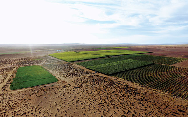
Brakfontein, which covers 10 000ha, is key to this larger project, as it is situated in the middle of the corridor.
“It was my job to approach Francois with the concept of creating a protected environment on his land,” explains Dreyer.
Van der Merwe says: “I suppose I’ve always been a conservationist at heart, because when Ben-Jon first approached me in 2019 with the idea of creating the protected area on our land, it immediately made sense to me.
“Being part of this Protected Area project makes me feel good, even if we aren’t really doing anything different with our farming. In future, I’d like to get more involved in environmental-awareness campaigns and ecotourism initiatives in my area.”
Once Van der Merwe and SANParks had an agreement on the basic principles involved, the WFA, with support from the World Wide Fund for Nature South Africa and the Leslie Hill
Succulent Karoo Trust, assisted him with a biodiversity assessment report. This eventually led to the drafting of a detailed Protected Area Management Plan (PAMP) for the farm.
A PAMP is one of the requirements for having an area officially declared a Protected Area in terms of the National Environmental Management: Protected Areas Act of 2003. As a landowner, Van der Merwe is responsible for the implementation of the PAMP, and SANParks is responsible for annual monitoring and evaluation of the management of the area.
Dreyer adds that SANParks can also assist with certain conservation activities, such as the clearing of alien species in the river courses.
Highlighting the undeveloped nature of the area, Van der Merwe recalls that when his father started farming on Brakfontein in 1983, the telephone hung from a tree!
“He bought the farm because of its proximity to the Doring River, as he wanted to establish pastures for the sheep, but we needed a dam for that, because the river runs dry during the hot summer months.
“However, the sheep alone couldn’t generate the cash needed for the construction of the dam.
“That drove the venture into raisin grapes. The dam was eventually completed in 2010.”
Over the years, Van der Merwe has expanded raisin grape production to 25ha, and has also moved into grape rootstock production on 9ha, onion seed on 2ha, and tomatoes for drying on 2ha. He also runs a herd of Bonsmara cattle.
Designated areas
The PAMP has divided the property into three categories: conservation areas, high-impact farming areas, and areas set aside for heritage protection. It also sets out specific approaches to the management of each area.
With the declaration of a protected area, the focus is on conservation of biodiversity, but sustainable commercial utilisation is also allowed.
“My commercial activities are not affected by the PAMP, because they’re separate from the land earmarked for conservation and heritage. We also included land in the high-impact area that I might want to develop over the next few years, so my farm planning can continue,” explains Van der Merwe.
In the case of Brakfontein, conservation involves careful monitoring of the natural vegetation and the impact of the livestock on the veld. The stocking rates and carrying capacity, for example, are worked out in greater detail than the general stocking rates available from the Department of Agriculture, Land Reform and Rural Development.
In consultation with grazing specialists from the Western and Northern Cape agriculture departments, botanists, commercial livestock farmers in the region, conservation agencies, academic institutions and NGOs, WFA produced a set of management guidelines specifically for the ecosystems of the Tankwa landscape. Land users, including livestock farmers and protected-area managers, can use these guidelines to manage the natural veld sustainably.
“It’s a problem if game numbers are too high, as we can’t manage them in the same way as livestock. The number of wild donkeys also needs to be monitored closely, as they’re highly destructive to our sensitive environment,” says Van der Merwe.
The PAMP also addresses the management of aquatic ecosystems and the protection of indigenous fish, and includes actions such as putting up information boards to inform anglers of the various fish species they might encounter, and their conservation status. The boards can also request anglers to catch and release indigenous species, but remove alien ones.
The plan sets out a time frame for carrying out a soil health census, during which any existing erosion is mapped, and areas with a high risk of soil erosion are indicated for future interventions.
Dreyer says that landowners who are part of the project often begin to realise the value of good stewardship of their properties, and also appreciate the benefits that come with their newfound conservation status.
“For example, the Section 37D [of the Income Tax Act] tax incentive that comes with declaring a nature reserve or contract national park is often a sweetener to declaring your [property as high-biodiversity value],” he explains.
The future
According to Dreyer, his function as liaison between landowners and conservation authorities is a large part of his work.
“These are long-term commitments, so landowners and conservation authorities consider their commitments and responsibilities in a very serious light,” he says.
He adds that the future of this conservation corridor lies in the hands of private landowners.
“Farmers will become more and more responsible for the protection of our natural heritage, and I want to play my part through this initiative.”
Email Francois van der Merwe at [email protected], or Ben-Jon Dreyer at [email protected].


