

A Global Positioning System (GPS) is a satellite-based navigation system made up of a network of 24 satellites placed into orbit by the US Department of Defence and made available for civilian use in the 1980s. A GPS needs an unobstructed view of the sky to work efficiently, and won’t work well near tall buildings or in forests. The Garmin Etrex is a tough and reasonably priced hand-held GPS which I would recommend for farmers. To view and compare prices in South Africa go to www.pricecheck.co.za
When it comes to software, I’d recommend the Garmin topographical maps which show all farms with their boundaries, enabling the farmer to measure distances and area on the map.
Using your GPS
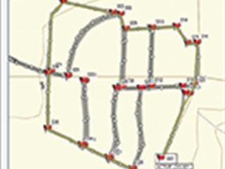
Once the GPS has been switched on and has picked up the satellites, it automatically stores positions (digital ‘breadcrumbs’). These are used to define a path or route (known as a ‘track’). You can travel with your GPS on and then simply download the breadcrumbs onto a map. The map will show exactly where the GPS has been, including speed (of the vehicle) and time of day of every position saved.
Waypoints
A ‘waypoint’ is one of a set of co-ordinates that precisely identify a location in physical space. A waypoint includes latitude, longitude and altitude. You create a waypoint by pressing a button on your GPS. This is initially a number, but can be customised and given a name. The GPS is a great tool for measuring the distances of fence lines, for example, by creating waypoints and uploading these to your PC.
This allows you to create a precise map of your farm, including camps or whatever is needed. Specific waypoints, such as pipelines and even joints in a pipeline which have been repaired, can also be stored. I can clearly remember digging for most of the day just to find a join in a pipeline which was blocked by roots. If the position had been saved on a GPS this could have been avoided.
You can also design stock watering systems, as the waypoints also record the altitude.
Contact Greg Miles at [email protected] with ‘Online Farmer’ in the subject line.


