

The contribution of unmanned aerial vehicles (UAVs) to sustainable agriculture is growing rapidly as the industry learns to harness this technology. According to Berkshire Hathaway’s Business Wire website, the global agriculture drone market was estimated to be worth US$2,15 billion (about R33 billion) in 2021, and this is projected to grow to US$6,72 billion (R103 billion) in 2026.
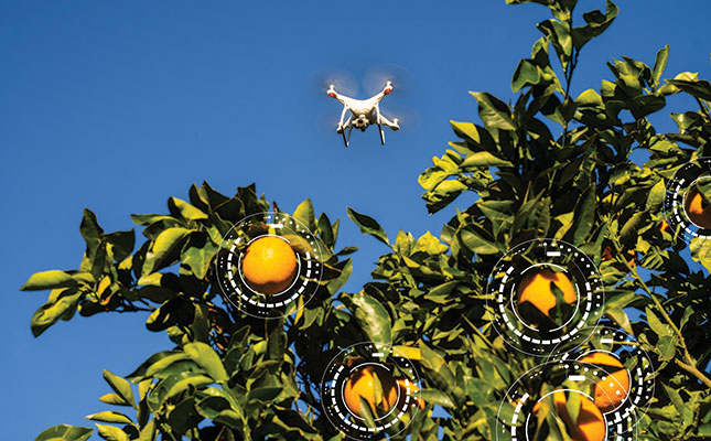
Since UAVs can survey extensive surface areas while pinpointing problems on a minute scale, they are far more efficient at inspecting orchards or lands than a farmer on foot. Moreover, their infrared sensors can detect problems not seen by the human eye.
Research on the impact of drones on precision agriculture conducted by Ibrahim Naji at the University of Texas in the US explains that plants reflect near-infrared (NIR) light, but that this ability deteriorates as the leaves die.
“Therefore, the NIR sensors are designed in such a way that they are able to monitor the difference [between] the NIR reflectance and visible reflectance, through a calculation known as the normalised difference vegetation index (NDVI). A strong NDVI is indicative of healthy plants in an area, while a weak NDVI can be interpreted as problem areas in a field.
“This can assist farmers in identifying diseased plants 10 days before the disease is noticeable by the human eye. In addition, the use of images from the drones helps farmers assess whether or not their plants have been attacked by pests, fungi, or weeds,” says Naji.
The ability to use the data collected by UAVs to make more accurate on-farm decisions bodes well for both profit and planet, as inputs can be reduced.
Naji adds that while hiring manned aircraft to survey fields is prohibitively expensive, particularly for smaller-scale farmers, drones are far more cost-effective, and this will ultimately benefit agriculture worldwide.
“Drones can provide farmers with information in a closer, highly accurate, affordable, and continuous perspective, which can be divided into manageable zones.
“Furthermore, they incorporate tools and specialised [data] that contribute to precision farming. Drones enable farmers to identify plants affected by diseases and pests at a faster pace than when using traditional methods, to monitor water during the irrigation process, and to apply fertilisers in different areas of the farm according to the needs of the soil.”
James Patterson, CEO of Aerobotics, a South African drone software developer, explains that while satellite imagery provides a blanket view, drones can zoom in on problems.
“A satellite pixel is equivalent to 1km², providing an average for an orchard. But drones allow you to get a far more granular image of around 3cm², so we can pick up individual trees and give a specific health reading for each one. This allows you to measure and track uniformity. The more uniform the trees in an orchard are, the easier it is to apply nutrients and water in a precise, uniform manner.”
Unprecedented accuracy
The use of drones improves crop monitoring, scouting and control. Collected data is more accurate, leading to more precise analytics of required farming information, and therefore better decision-making. If used appropriately, it can lead to larger returns on investment by improving the quality and quantity of the yield.
Patterson recalls how this technology helped one farmer lift his overall yield.
“Analysing the data we obtained, we noticed a discrepancy between citrus trees on the north side of the farm and those on the south. We sized the fruit from each side, and those from the healthier, northern section were a whole size scale larger. A fruit-sampling exercise showed that the southern half of the farm yielded around 30t/ ha, whereas the northern half produced 44t/ha.
“Not only did this reduce the farmer’s profit in terms of lower yield, but the smaller fruit didn’t make export grade, further reducing income.”
These insights were obtained using a variety of UAV technologies. Since plant health and transpiration are translated directly into fruit size, tonnage and thus profit, thermal cameras were used to assess orchard health.
“The thermal cameras attached to the drones measure ambient temperatures in the orchard. This is compared with the temperature of the individual tree, so we can track how well it is transpiring; that is, moving water through its system. Poor transpiration is an indicator of stress that differs from simply measuring the chlorophyl level through NDVI, and is more closely related to the plant’s use of water.
“Thermal imagery can therefore be used to detect problems with the irrigation system, enabling the farmer to make adjustments to ensure that all plants receive the same volume of water and use it effectively before too much damage is caused.”
Patterson notes that by harnessing such advanced technology, farmers can take action more rapidly while using less manpower.
“All the algorithms between the sensors translate into a map on which you can view every tree on the farm and determine health metrics through colour scales. So you can immediately see patterns and problem areas, and plan your in-field actions accordingly.
Farm managers and workers can then scout these areas to understand why there are problems. This reduces the time to find and implement a solution, and also decreases the workload because workers are guided directly to the problem.”
Data analysis
Understanding the data is crucial to the success of implementing UAV technology. This means that farmers should carefully consider how and when information is provided when choosing a service provider, or running the technology themselves.
Patterson says that success comes from being able to make the necessary adjustments at the right time.
“Farmers need to be able to view orchards at certain times throughout the season to ensure they’re being managed optimally through different phenological stages. Flyovers should be set for certain times, such as pre- and post-harvest, and during the season, when fertigation levels are vital.”
Another advantage of a drone is that it can map a large farm within just two days, far quicker than what can be done on foot or with a manned aircraft. After this, it’s important to transform the insights into action as soon as possible.
“You can then take data-driven actions, rather than relying on a rotational plan where you systematically move through the entire orchard to inspect trees. There’s a huge saving of time and resources, because you can allocate resources where they matter,” says Patterson.
The system also allows for more targeted inputs rather than blanket applications. This benefits the environment, which in turn helps to make the farm more sustainable.
“The data can be used in variable rate application programmes, so inputs can be targeted in terms of health zones and hence reduced.”
Managing soil erosion
Protecting soils starts with a better understanding of soil profiles and areas that are susceptible to erosion. Naji notes that 3D maps generated by drones can help farmers determine soil health.
“The data they obtain are crucial in maximising yields, as farmers gain greater understanding of the most fertile soils, and those that require improvement. Identifying hotspots for erosion and acting before they become a bigger problem is a key benefit.”
Dr Jay le Roux, senior lecturer in geography at the University of the Free State, adds that the advent of UAV technologies offers considerable potential for assessing soil erosion, including the erosion rate and transport of sediment.
Recent improvements include integrated UAVs that utilise photogrammetric payloads and structure-from-motion stereographic software. Here, overlapping images with sub- centimetre resolution can be obtained to create high-resolution digital surface models of erosion features. This can be used to determine the extent and dimensions of erosion features, where sediment is generated, and where it is deposited.
During a study that Le Roux conducted in the Mzimvubu River catchment in the Eastern Cape, satellite imagery proved its worth in identifying gully erosion susceptibility of the area.
“Gully erosion is one of the most severe types of erosion. In this catchment there are thousands of gullies, potentially feeding massive amounts of sediment into the river network.
“This puts the estimated life expectancy of the Ntabelanga Reservoir at less than 50 years, should there be no effective siltation and catchment management measures. But restoration resources are usually limited, and strategic information on erosion-susceptible areas is required to avoid further degradation,” he explains.
By using satellite technology to model areas that are susceptible to gully development, Le Roux could estimate the sediment yield potential from the susceptible areas. The results showed that more than 30 000ha (7%) of the catchment consisted of drainage paths with a large contributing area and erodible soils, and were thus intrinsically susceptible to further gully development.
If not protected, these susceptible areas could add 300 million cubic metres of sediment to the river network, reducing the volumes of the Ntabelanga and Lalini dams by 51% and 59% respectively.
Technologies that assist farmers in better managing resources while optimising yields are advancing rapidly.
And as land and water become scarcer, farmers need to manage what they have more effectively, using the best tools at their disposal. UAVs can make a profound difference in this regard, and the sooner farmers familiarise themselves with the technology, the better.
Email James Patterson at [email protected], Ibrahim Naji at [email protected], or Dr Jay le Roux at [email protected].


